San Diego's New Flood Maps Just Pulled Thousands of Homes Into Mandatory Insurance (2026)
For decades, a home in Pacific Beach, Mission Beach, Bird Rock, or La Jolla Shores could sit a few blocks from the ocean and still carry no flood insurance requirement at all, sitting in FEMA's Zone X, the standard designation for low to moderate risk. That changed on March 3, 2026. FEMA's updated Flood Insurance Rate Maps for the City of San Diego, Santee, and surrounding jurisdictions reclassified significant portions of those coastal communities from Zone X into Zones AE and VE, the designations that trigger mandatory flood insurance for anyone with a federally backed mortgage. If you own, are buying, or are selling a property anywhere near this stretch of coast, this isn't a bureaucratic footnote, it's a change that can add a real annual cost to a home that had none before, and it's already showing up in escrow.
What actually changed, and where
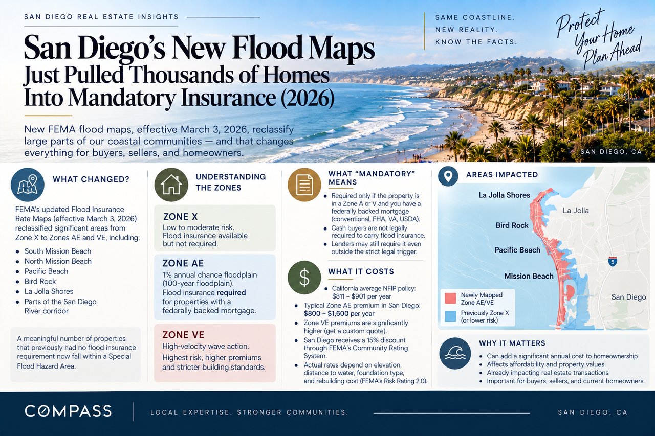
FEMA's update is technically called a Physical Map Revision, a formal process where the agency re-surveys flood risk using updated topography, wave modeling, and rainfall data, then republishes the Flood Insurance Rate Maps that lenders and insurers rely on. The March 2026 revision reclassified large sections of South Mission Beach, North Mission Beach, Pacific Beach, Bird Rock, and La Jolla Shores from Zone X into Zone AE, the standard high-risk designation covering the 1 percent annual chance floodplain, commonly known as the 100-year floodplain, and in some of the most exposed coastal segments, into Zone VE, a stricter designation reserved for areas facing high-velocity wave action during a flood event. The update also touched flood risk mapping further inland along stretches of the San Diego River corridor, though the clearest before-and-after change for most owners has been along this specific coastal band, where a meaningful number of properties went from carrying no flood insurance obligation to falling squarely inside a Special Flood Hazard Area overnight.
Zone X versus AE versus VE, and why the letter matters
The zone designation isn't just a label, it's what determines whether flood insurance is legally required and how a policy gets priced. Zone X covers areas FEMA considers low to moderate risk, where flood insurance is available but not mandated by federal law. Zone AE covers the base floodplain, areas with a 1 percent annual chance of flooding in any given year, where insurance becomes a federal requirement for anyone financing the purchase with a federally backed loan. Zone VE sits a tier above that, applied to coastal areas that face not just flooding but high-velocity wave action capable of causing structural damage beyond standing water, and it typically carries higher construction standards and meaningfully higher premiums than an equivalent AE-zone property. A home that moved from X to AE saw its insurance status shift from optional to required. A home that moved from X to VE saw both that shift and a jump into the most expensive, most restrictive tier FEMA maps for residential property.
What "mandatory" actually means in practice
The legal trigger is narrower than a lot of owners assume. Flood insurance is federally required only when a property sits in a high-risk Special Flood Hazard Area, meaning a zone beginning with A or V, and the buyer is using a federally backed or federally regulated mortgage, which covers the overwhelming majority of conventional, FHA, VA, and USDA loans in this market. A cash buyer isn't legally obligated to carry it, and a property still mapped in Zone X isn't required to carry it either. In practice, though, many lenders now ask about flood zone status on any coastal property as a matter of underwriting caution even outside the strict legal trigger, and any buyer financing a purchase in one of the newly reclassified pockets should expect their lender to require proof of an active policy before closing, not after.
What this is actually going to cost
Flood insurance in California runs meaningfully cheaper than the national picture, with the average NFIP policy statewide costing somewhere between $811 and $901 a year, well under the national average that runs into the thousands in higher-risk states. For a standard single-family home in a Zone AE designation, premiums typically land in the $800 to $1,600 a year range, and San Diego property owners get a built-in advantage on top of that: the city's participation in FEMA's Community Rating System, a voluntary program that rewards local floodplain management efforts, currently earns every NFIP policyholder in the city an automatic 15 percent discount off the standard premium. Zone VE properties, given the added wave-action risk, run meaningfully higher than the AE range and should be quoted individually rather than estimated off an AE benchmark. Under FEMA's current Risk Rating 2.0 methodology, the actual premium a specific property receives isn't just a function of its zone, it factors in distance to the nearest water source, first-floor elevation, foundation type, and rebuilding cost, so two homes a few doors apart in the same zone can see genuinely different quotes.
The newly mapped discount, and why timing matters
FEMA builds in a real cushion for properties caught in a remapping like this one. If your property was newly added to a high-risk zone by this March 2026 revision, you're eligible for what's called the newly mapped discount for the first 12 months after the new maps took effect, a meaningfully reduced premium compared to the standard Zone AE or VE rate. FEMA also waives the usual 30-day waiting period for a new policy specifically when the purchase is triggered by a map change, meaning coverage can begin as soon as the next business day rather than forcing a month-long gap between application and effective coverage. Owners in the affected communities who haven't yet purchased a policy are, in effect, sitting on a discount window that narrows every month that passes from the March effective date, which makes this worth acting on rather than waiting to see if it becomes relevant during a future sale.
Grandfathering can protect owners who already had coverage
For owners who carried an NFIP policy on their property before the remapping, FEMA's grandfathering provision allows them to keep their prior, lower-risk rate class rather than being immediately bumped to the new zone's higher pricing, as long as coverage has been continuous. This is a meaningful protection for longtime owners who bought when their home sat in Zone X and kept a policy in place out of caution even though it wasn't required at the time. On top of that, the Homeowner Flood Insurance Affordability Act caps how fast NFIP premiums can rise for a primary residence, limiting annual increases to 18 percent even as FEMA's broader Risk Rating 2.0 system continues phasing in more granular, and in many cases higher, pricing nationwide.
The disclosure piece both sides need to get right
California already requires sellers to disclose a property's flood zone status as part of the state-mandated Natural Hazard Disclosure Statement, the same report that covers wildfire, seismic, and other hazard zones referenced elsewhere on this blog. The problem this remapping creates is timing: an NHD report pulled before March 3, 2026 reflects the old Zone X designation for a property that's now sitting in AE or VE, which means a report that was completely accurate a few months ago can be quietly wrong today. Any transaction currently in progress, or any listing that's been sitting on the market since before the update, needs a current natural hazard report pulled after the effective date, not one generated earlier in the process.
What this means if you're buying near the affected coastline
Before writing an offer on anything in Pacific Beach, Mission Beach, Bird Rock, or La Jolla Shores, confirm the property's current flood zone directly through the city's floodplain management office or FEMA's map service center rather than relying on a listing sheet that may predate the update. If the property was newly reclassified, get an actual insurance quote before you're deep into escrow, since the number can meaningfully change your real monthly carrying cost even though it won't show up in the listed price. And if you're financing with a federally backed loan, build the lender's flood insurance requirement into your timeline early, since it's now a closing condition on properties that didn't require it a year ago.
What this means if you're selling near the affected coastline
Pull a current Natural Hazard Disclosure Statement rather than reusing one from earlier in the year, since an outdated flood zone designation on a legally required disclosure is exactly the kind of issue that can unravel a deal late in escrow once a buyer's lender catches it independently. If your property was newly mapped into a high-risk zone, get ahead of the conversation rather than letting a buyer discover it during their own diligence, since a seller who can hand over an actual insurance quote and explain the newly mapped discount window looks far more credible than one who seems caught off guard by their own city's map update.
The bottom line
FEMA's March 2026 remapping moved real San Diego neighborhoods, not hypothetical ones, out of a category that required no flood insurance and into one that does, with Pacific Beach, Mission Beach, Bird Rock, and La Jolla Shores absorbing the clearest impact. The actual cost is manageable, generally $800 to $1,600 a year for a standard Zone AE policy before San Diego's 15 percent community discount, but the newly mapped discount window and the 30-day waiting period waiver both reward owners who act promptly rather than waiting for a future sale to force the issue. If you're trying to figure out whether a property you own or are considering fell into the new flood zones, reach out and we'll go through what actually changed and what it means for your specific address.